


Sea & Soul Chesapeake Bay Nautical Wall Art | Coastal Décor 3D Wood Map 13-in x 16-in | Nautical Wood Chart | Lake Art | Handcrafted in the USA (Rustic Pine/Deep Blue)
$199.00 (as of 01/17/2026 15:34 PST - DetailsProduct prices and availability are accurate as of the date/time indicated and are subject to change. Any price and availability information displayed on Amazon at the time of purchase will apply to the purchase of this product.)
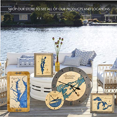
MADE IN THE USA –3D Wood Maps are handcrafted completely & proudly in the USA by the longest running manufacturer of bathymetric art in the country.
Description
- MADE IN THE USA –3D Wood Maps are handcrafted completely & proudly in the USA by the longest running manufacturer of bathymetric art in the country.
- INTRICATE LASER PRECISION – Topographic nautical maps are drawn by our artist using a combination of maps then laser cut and engraved in beautiful detail. Each chart is hand stained and assembled by our craftsmen with the water depicting the bathymetric depth contours, one level below the shoreline.
- HIGHEST QUALITY & CRAFTSMANSHIP – Overall measurement is 13”x16,” Baltic Birch face wood nautical map measures 11"x 14." Solid 1” rustic Pine frame is harvested and milled by the Amish of Wisconsin.
- FULLY ASSEMBLED AND READY TO DISPLAY– Hang individually or select a few of our nautical wood charts to create a collage of all your favorite destinations! Framed pieces stand on their own so this size is also perfect as a mantle or book shelf accent adding to any coastal or waterfront decor.
- BEST SELLING UNIQUE GIFTS – Sea & Soul Nautical Chart Art makes the perfect unique gift for a waterfront wedding, a thank you gift for a wonderful weekend at the lake or an anniversary gift – 5th Anniversary is the gift of wood!
Additional information
| Brand | Sea & Soul |
|---|---|
| Manufacturer | Sea & Soul |
| Product Group | Home |
| Color | Rustic Pine/Deep Blue |
| Product Dimensions | 13 x 2 x 16 inches |
| Item Weight | 2 pounds |
| Size | 16"L x 13"W |
| Unit Count | 1 |
Related products
-

Historic Map : U.S. Coast Survey Nautical Chart or Map of The Florida Keys and Key West, 1859, Vintage Wall Art : 24in x 32in
$59.99 Learn More -

ArtDirect Nautical Chart – Cape Cod Bay ca. 1970 14×11 UnFramed Art Print Poster Ready for Framing by NOAA Historical Map and Chart Collection
$19.99 Learn More -

Historic Pictoric Vintage Map – Connecticut River, 1977 Nautical NOAA Chart – Connecticut (CT) – Vintage Wall Art – 20in x 24in
$49.99 Learn More -

Historic Pictoric Map – Islands in Lake Erie Including Sandusky Bay, Ohio, 1931 Nautical NOAA Chart – Ohio (OH) – Vintage Wall Art – 16in x 24in
$49.99 Learn More