


HullSpeed Designs Charleston Harbor & Approaches 1977 – Vintage Map Reproduction – Nautical Decor – Wall Art (13"x19")
$19.95 (as of 01/05/2026 15:34 PST - DetailsProduct prices and availability are accurate as of the date/time indicated and are subject to change. Any price and availability information displayed on Amazon at the time of purchase will apply to the purchase of this product.)
Add style to any room’s decor with this classic map. Perfect Gift for your Home or Office.
Description
- VINTAGE MAP REPRODUCTION: Add style to any room’s decor with this classic map. Perfect Gift for your Home or Office.
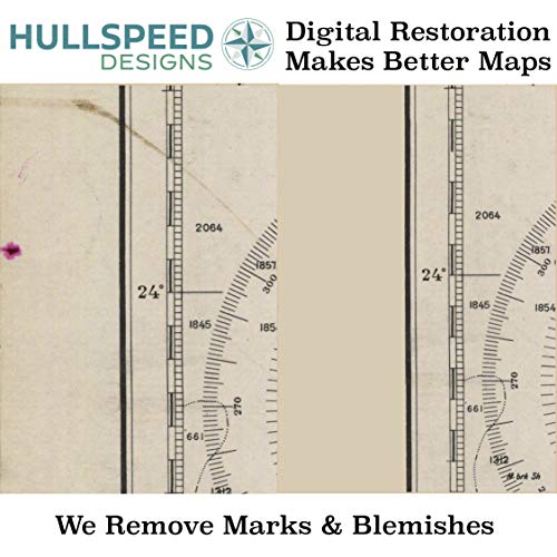
- METICULOUSLY RESTORED: Our nautical charts and maps are digitally restored to remove imperfections (creases, smudges, tears, discoloration caused by age, non-original stamps, etc.). The result is a gorgeous map reproduction true to its period. Made in the USA.
- HEAVYWEIGHT PAPER: Printed on high-quality paper with a smooth matte, non-glare finish. The paper used for 18”x18” prints and larger is an acid-free 32lb bond. Prints 13”x19” and smaller are printed on sturdy acid-free card stock.
- PROFESSIONAL GRADE INK: Acid-free professional grade ink provides a rich and authentic color and ensures that the prints will not fade over time.
- READY TO FRAME: Save on custom framing! Maps fit easy-to-find standard frames 11×14, 13×19, 18×24, 24×36. Larger sizes available. All prints are packaged and shipped in sturdy tubes or envelopes to offer guaranteed protection.
Additional information
| Brand | HullSpeed Designs |
|---|---|
| Manufacturer | HullSpeed Designs |
| Product Group | Home |
| EANs | 0642554817408 |
| UPCs | 642554817408 |
| Item Part Number | Charleston-1977-13×19 |
| Size | 13×19 |
| Unit Count | 1 |
Related products
-

Historic Pictoric Vintage Map – Point Judith Harbor, 1998 Nautical NOAA Chart – Rhode Island (RI) – Vintage Wall Art – 36in x 44in
$109.99 Learn More -

ArtDirect Nautical Chart – Cape Cod Bay ca. 1970 14×11 UnFramed Art Print Poster Ready for Framing by NOAA Historical Map and Chart Collection
$19.99 Learn More -

Historic Pictoric Vintage Map – Connecticut River, 1977 Nautical NOAA Chart – Connecticut (CT) – Vintage Wall Art – 20in x 24in
$49.99 Learn More -

Historic Pictoric Map – Islands in Lake Erie Including Sandusky Bay, Ohio, 1931 Nautical NOAA Chart – Ohio (OH) – Vintage Wall Art – 16in x 24in
$49.99 Learn More